Public itches for plan on bypass signs at wayfinding meeting
Published 8:51 am Thursday, September 21, 2017
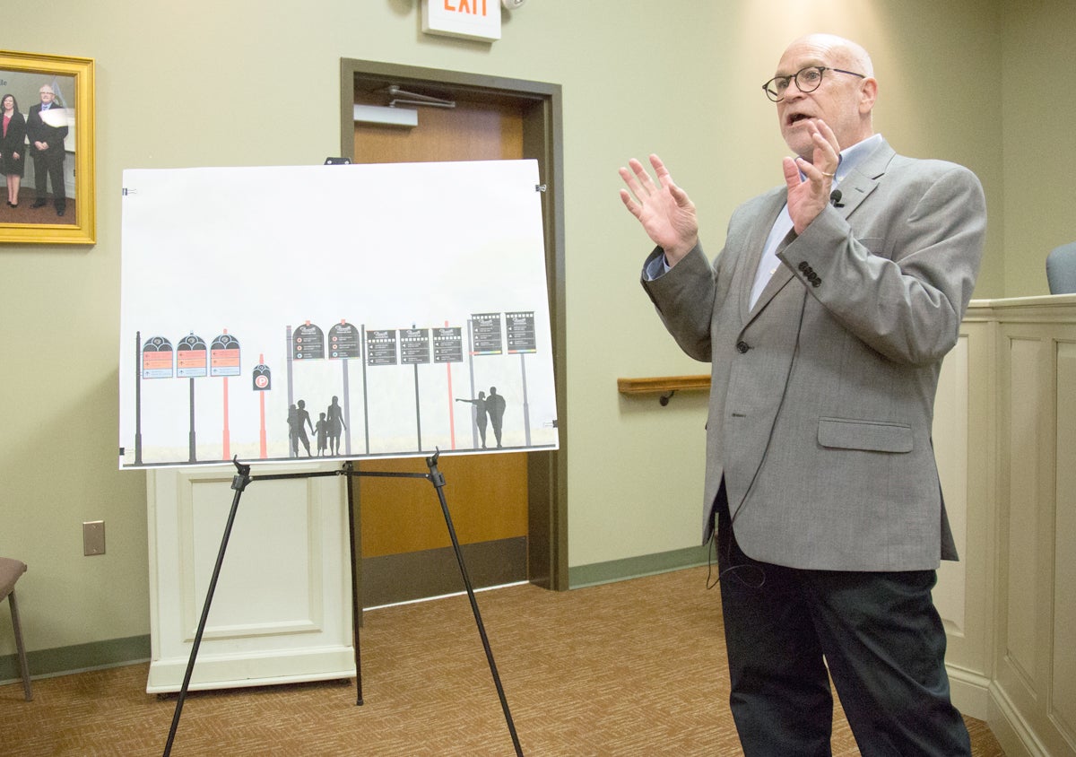
- Ben Kleppinger/ben.kleppinger@amnews.com Wayfinding consultant John Carman talks Tuesday night about the different styles that could be used in a redesign of Danville's signs.
Work on a master plan for signs in Danville continued with a public meeting Tuesday night, but the members of the public most invested in the outcomes were left waiting for answers again.
The “wayfinding master plan” is being developed by the consulting company Carman and its lead consultant, John Carman; Danville is paying $27,000 for the plan. The outcome will be a state-approved plan for new signs pointing people to places of interest throughout Danville and Boyle County from key “decision point” intersections.
Many of those who attended the first wayfinding public meeting in June returned for Tuesday’s meeting, with the same question in the forefront of their minds: What locations will get prime placement on the signs along the Danville bypass?
Carman led off the 90-minute meeting by summarizing the work done at the June meeting, when participants listed the locations they thought were most important to identify to travelers. And he restated a major limitation he says Danville faces: signs along non-local roads can only point to three locations, according to federal regulations.
“Just about all the streets — the primary routes within Danville are state highways and you have to comply with the federal guidelines for signs,” he said. “… There might be some cases where we might be able to get a waiver for maybe four locations, but we’ll get into that later.”
Carman said locations in Danville have been divided into two tiers — locations outside of the immediate downtown area (tier one) and locations in the downtown area (tier two).
“Community and institutional destinations will take priority when further out in the community,” Carman said. “We’re calling kind of the outlying areas, outlying from downtown, we’re calling those the tier one locations.”
“Then as we come in towards the center of town, the priorities begin to change,” Carman continued. “And we begin to allow people to focus in on specific locations or destinations.”
Paula Fowler, executive director of the Chamber of Commerce, asked for examples of tier-one locations.
“Downtown, Centre College, the hospital, maybe KSD,” Carman said. “Then as we get closer into town, then maybe we say city hall, or the Dollhouse Museum, or Jacobs Hall or Admiral Stadium — as we get in closer to the core.”
Lori Kagan-Moore, owner of the Great American Dollhouse — one of the local attractions hoping for some exposure on the bypass, asked Carman why the plan seemed unchanged based on input from the last meeting.
“This is kind of what you talked about last time with putting those more generic things on the bypass before you get closer in,” she said. “There were 20-some people here who talked about wanting that not to happen and wanting you to address that.”
Carman said “we’re not necessarily scattering signs all around the bypass, but we’re going to be looking at critical locations and we’ll get into that — those recommendations.”
The explanation of tier one and tier two and what recommendations would be for bypass signs seemed to change later in the meeting, when Kagan-Moore and representatives for Pioneer Playhouse — Heather and Robby Henson — pressed Carman on the issue.
Carman asked those in attendance to participate in a voting exercise to choose sign designs that they liked.
“Not to beat a dead horse, but I just want to clarify because (this meeting is only supposed to last) an hour and a half … and you have an exercise for us that talks about the design choices and what we think about the legibility and these different things, which seems like a good idea,” Kagan-Moore said. “But … most of the people that I think are here are very interested in things like what’s going to be sign on the bypass — that was the big theme that was come to, and I want to make sure that’s not getting pushed into the last 10 minutes.”
Carman said if the group would take “5 or 10 minutes” to do the exercise, “that gives us 45 minutes to talk about the rest.”
But before the exercise took place, Heather Henson and others questioned Carman further about bypass signage, asking about why the limit of three places per sign had to be followed and how many different signs could be put up.
Carman said a “federal standard” prevents additional items from being listed on each sign. “We’re not making decisions tonight. … We’re going to talk about where we think the critical sign locations will be but we’re not going to — the next meeting will be ‘what’s going to be on that sign?’
Carman said the city could put up lots of signs “if it would be allowed, but I’m not inclined to do that because then you begin to lose the effectiveness.”
“We’ve made some decisions — wrong word. We’ve made some recommendations of where the critical signs should be.”
“But not what will be on them?” Kagan-Moore asked. “Is that what you just said?”
“That’s right,” Carman responded.
“So in other words, to this meeting you’re not bringing more of an opinion about what will be signed on the bypass than last time?” Kagan-Moore asked.
“Uh — no,” Carman said.
“OK, that’s something we keep asking for. It seems to be the concern,” Kagan-Moore said.
“It’s a process,” Carman said.
The participants were soon riled again by comments from Carman that while no recommendations were being made at the meeting for removal of any brown attraction signs in the Danville area, “we may be removing some brown signs.”
“There are a lot of brown signs out there that people have paid for,” Fowler said. “So part of this process may be removing some of those?”
“It could be, unless there’s objections,” Carman said.
“So Wilderness Trail Distillery, which has a sign up, may or may not stay?” Fowler followed up.
“I’m not suggesting that it’s going, but I’m not suggesting that it would stay,” Carman said.
“That’s, like, way far ahead in the process,” City Engineer Earl Coffey said. “What we’re trying to do is allow him to manage a process and select a style of sign.”
Coffey said the public meetings are “more of a steering committee approach” and trying to discuss what signs will include which locations is “jumping all the way to the end.”
As Carman continued his presentation, audience members continued to press him on how he was referring to tier one and tier two locations and examples he was giving of signs with specific locations on them. They questioned why locations identified as a high priority in the June meeting weren’t appearing on the mock sign images or in Carman’s examples.
Carman eventually displayed a map showing the locations identified in tier one, including Millennium Park, Henry Jackson Park, Admiral Stadium, Perryville Battlefield, Boyle County High School, Wilderness Trail Distillery, Pioneer Playhouse and the industrial park.
Once again, Kagan-Moore and others got the impression from Carman that tier one locations were a priority for signage on the bypass and complained.
“This is an example of categories,” Carman said. “We’re not saying that these are — we’re not saying that some tier twos would not be located in tier one. We’re giving an example — this is a geographic discussion of where places are located and what they are.
“We’re going to show the Dollhouse Museum in tier two. That doesn’t mean that is going to be exclusively located in tier two. Apparently I’m doing a poor job of communicating this, but I apologize. This is geographic only; this has nothing to do with what’s going to be on a sign and where.”
Tier two destinations provided by Carman included Centre College, the Norton Center, the Dollhouse Museum, Danville City Hall, the Community Arts Center, the Boyle County Courthouse, the Boyle County Public Library, parking, the McDowell House Museum, Constitution Square Park, Farris Stadium and Ephraim McDowell Regional Medical Center.
Carman provided complex maps showing where individual signs could be located approaching different “decision point” intersections, and said in subsequent meetings, the public will be given “five or six options” for what might appear on each sign.
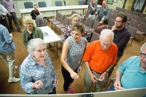
Ben Kleppinger/ben.kleppinger@amnews.com
Members of the public participate in a voting exercise Tuesday night to express preferences for styles of signs that may be used in Danville’s wayfinding master plan.
“That can be a very difficult discussion. There’s going to be disagreement. You’ll probably disagree with my thoughts, but I wanted to hear your all’s thoughts first. I have my own opinions,” he said. “… The next step is probably another hour-and-a-half to two-hour discussion in itself, but we felt that it’s better to ease into this, whether you agree with me or you like what I said — maybe understanding it is the bigger issue.
“I think that it’s better to take this sequentially. I’m hearing everything you’ve said. I can assure you of this. And a lot of the comments I’m sure will be carried forward and might be more appropriate at the next discussion or two discussions from now. But this project is not going to be implemented, we’re not going to seal this all up until we’ve gone through all this.”
Carman said at the end of the meeting that the discussions are “not unusual” for the wayfinding master plan process, which he has been through before.
“We are deliberately taking this slow so that we can hear your voice and so that we are not designing in a vacuum,” he said.
The date of the next wayfinding public meeting is expected to be announced at Monday’s Danville City Commission meeting.
SO YOU KNOW
The locations of importance voted on at the first wayfinding public meeting were presented Tuesday night in three categories, based on how many people said they were important to include on wayfinding signs:
• Highly chosen: Community Arts Center, Norton Center for the Arts, Dollhouse Museum, Pioneer Playhouse, Centre College, Constitution Square and “downtown shops and restaurants.”
• Moderately chosen: Ephraim McDowell House, Millennium Park, Boyle County Public Library, Perryville Battlefield, Danville City Hall, Wilderness Trail Distillery, Boyle County Courthouse, “parking” and Ephraim McDowell Regional Medical Center.
• Others chosen: Danville-Boyle County Visitor’s Center, West T. Hill Community Theater, Boyle County High School, Kentucky School for the Deaf, Danville High School, “trails,” “parks,” Weisiger Park, Jacobs Hall, industrial park, Bluegrass Community and Technical College and Henry Jackson Park.
More News


SportsPlus
How to Pick the Predators vs. Kraken Game with Odds, Spread, Betting Line and Stats – October 15
The contest between the Nashville Predators and the Seattle Kraken at 8:00 PM ET on Tuesday has a…
How to Watch the MLB Baseball Playoffs on Monday, Oct. 14: TV Channel, Live Streaming, Start Times
The MLB Playoff outings in a Monday schedule that shouldn’t be missed include the New York Mets squaring…
Pacers vs. 76ers Tickets Available – Sunday, Oct. 27
The Indiana Pacers take on the Philadelphia 76ers on Sunday, October 27, 2024 at 3:30 PM ET. The…
Kentucky vs. Florida Oct. 19 Tickets & Start Time
The Florida Gators will face a conference opponent when they host the Kentucky Wildcats on Saturday, October 19,…
MLB Playoff Betting Lines and Picks Today | Oct. 14
The MLB Playoff matchups in a Monday slate that shouldn’t be missed include the New York Mets squaring…
