Junction City future land-use map preview Saturday
Published 8:00 pm Tuesday, June 18, 2019
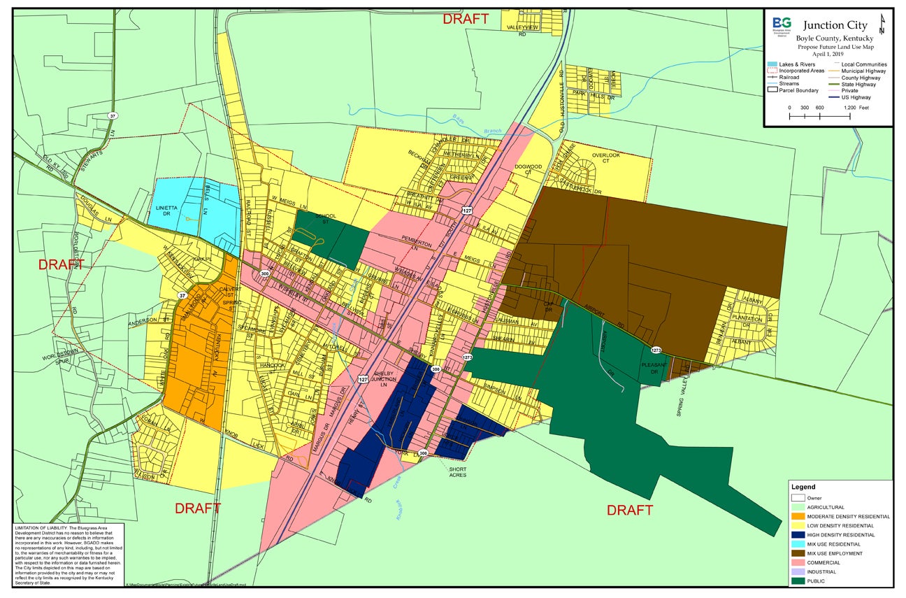
- Map courtesy of P&Z The proposed future land use map (FLUM) for Junction City shows, agricultural zones in light green; moderate density residential in orange; low density residential in yellow; high density residential in dark blue; mix use residential in light blue; mix use employment in brown; commercial in pink; industrial in light purple and public in dark green.
Junction City residents and property owners will have a chance to inspect a draft of what the town’s future development could look like if the proposed Future Land Use Map (FLUM) is approved.
The map will serve as the primary guide for Junction City and the surrounding area’s development for the next 10 to 15 years, according to Danville-Boyle County Planning and Zoning Director Steve Hunter.
From 9 a.m. to noon on Saturday, the public is invited to an open house at the Junction City Community Center to see the map, ask questions and voice their opinions.
“I think anybody who resides or owns property in Junction City, or on the fringe or southern part of Boyle County,” should be interested in what the map shows where different types of residential and commercial areas could be located, Hunter said.
The map is for future possible development, Hunter explained — “It’s not changing the zoning.” However, the FLUM would be the basis for the P&Z Commission to make a decision, if or when a developer wants a zone change, Hunter said.
Members of the FLUM committee have worked for nearly a year labeling land uses all over the Junction City community. They looked at and studied where they thought were the best areas for commercial development, job-based opportunities and where low-, moderate- and high-density residential areas should be located or protected in the future, Hunter said.
During Saturday’s informal open house, P&Z staff and FLUM committee members will be on hand to talk “one on one” with residents and property owners about their opinions on and ideas for future land use. They’ll also explain what each designation means.
Hunter will have copies of the FLUM on-hand for people to take with them, and he said he’d email information if someone wanted it.
Hunter said public input is good because “they know more about their own town than the planner does in Danville.”
The map being presented Saturday is a “better looking map” than the one Junction City had in 2007, Hunter said. The new FLUM “is more generalized. It’s blended.” Instead of each parcel being labeled as commercial, then right next door residential — which really just showed existing land use patterns — the new map “is more generalized. It has a better flow. There are better transitions from U.S. 127 to neighborhoods,” Hunter said. “Junction City’s map is a work of art.”
One of the unique features of Junction City’s FLUM is a huge area designated as “mixed-use employment.” This area is located adjacent to the airport, Hunter said. “It’s a flexible category,” which could be used for commercial or industrial development that is “employment based,” Hunter said. Being able to leverage the airport amenities and location on a state road “makes sense in the future. … They could hand it off to the Economic Development Partnership if Junction City wants to see growth in that general area.”
More News Main


SportsPlus
How to Watch MLB Baseball on Friday, July 26: TV Channel, Live Streaming, Start Times
Today’s MLB slate has several top-tier games, including a matchup between the Cleveland Guardians and the Philadelphia Phillies.…
How to Watch the Reds vs. Rays Game: Streaming & TV Channel Info for July 26
The Cincinnati Reds and Rece Hinds hit the field at Tropicana Field against Randy Arozarena and the Tampa…
Reds vs. Rays: Betting Preview for July 26
When the Tampa Bay Rays (52-51) and Cincinnati Reds (49-53) match up in the series opener at Tropicana…
Tennessee Titans vs. Los Angeles Chargers Week 10 Tickets Available – Sunday, November 10 at SoFi Stadium
On Sunday, November 10, 2024, the Los Angeles Chargers (0-0) and the Tennessee Titans (0-0) clash at SoFi…
Tennessee Titans vs. New England Patriots Week 9 Tickets Available – Sunday, November 3 at Nissan Stadium
On Sunday, November 3, 2024, the New England Patriots (0-0) go head to head with the Tennessee Titans…
